| Travel / Tourist Attractions |
Þingvellir National Park, Iceland
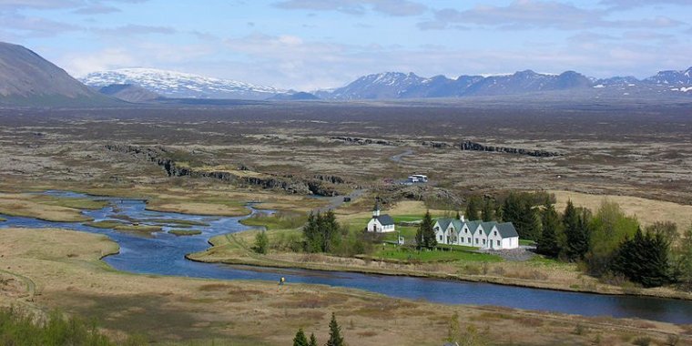
Þingvellir National Park, Iceland. ![]()
The park is home to the world's longest running Parliament, first established in 930 AD, and also has a dramatic landscape formed as a result of sitting along the border between the North American and European tectonic plates.
The Þingvellir area forms part of the volcanic fissure zone running right through Iceland, In turn, this zone is part of the tectonic plate boundaries of the Mid-Atlantic Ridge, which extend the length of the Atlantic from north to south.
The Þingvellir plains are the westernmost part of a rift valley stretching from the mountains in the northeast and down towards lake Þingvallavatn. The horsts delimiting the valley are the cliffs of Almannagjá fault to the west and the Heiðargjá fault to the east. Over the past 10,000 years the valley’s appearance has been shaped by the spreading and sinking of the Earth’s crust.
The tectonic plates west of Almannagjá and east of Heiðargjá are gradually moving apart by an average of 3 mm per year. Measurements suggest that the graben (the floor of the valley) has widened 70 m in the space of 10,000 years, and sunk by 40 m at the same time – the difference between the top of Almannagjá and the plains below.
As well as moving gradually, the land displaces at intervals of several hundred years. In 1789 Þingvellir was struck by a wave of earthquakes lasting ten days. The valley floor between Almannagjá and Heiðargjá sank by almost 2 m then, mostly in the middle, and spread considerably too.
Lake Þingvallavatn
Þingvallavatn is the largest natural lake in Iceland, with a surface area of 84 square kilometers. It lies at an altitude of around 100 m above sea level. At its deepest point it measures 114 meters, while the average depth is 34 meters. There are three islands in the lake. Almost nine-tenths of the water inflow comes from springs and fissures on the bed of the lake or at its shore. The wide underground catchment area for water extends as far as Langjökull glacier. Only one-tenth of the inflow is surface water from brooks and rivers, the largest of which is Öxará. Average outflow at the only drainage point, the river Sog, is around 110 m³ per second.
The Lake Þingvallavatn biosphere clearly testifies to the fact that it straddles on the border between the continents of Europe and North America. The great northern diver, a bird native to North America, breeds around the lake and gathers in flocks at the lake in autumn. Other migrant birds from North America are barrow’s goldeneye and the harlequin duck. White-tailed eagles nested on the slopes of Dráttarhlíða and Arnarfell in olden times, but are rarely seen now. Mink live by the lake, preying on small birds and foxes make occasional appearances.
The greatest biological wonder at Þingvallavatn, however, is its fish population. No other lake in the world supports four separate species of arctic charr. At the top of the food chain is the brown trout. Some brown trout are known to have weighed more than 30 lb (14 kg), but even at their peak, the average was around 11 lb (5.0 kg). However, the fish stocks in the lake went into serious decline after the upper Sog river was harnessed for hydroelectricity production in 1959, which disrupted the largest spawning grounds of the brown trout. Large brown trout can still be seen in Öxará, however, during the autumn spawning season.
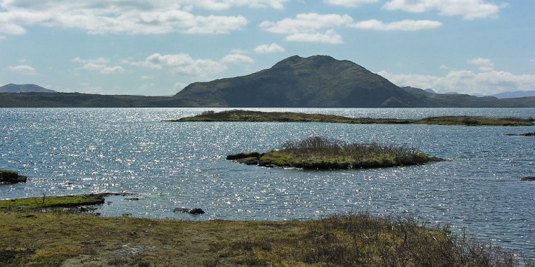
Þingvallavatn. ![]()
Flora and fauna
Birch woodland is characteristic of the Þingvellir area, indicated by the original name of the area in Icelandic: Bláskógar (literally "Blue Woods"). In the National Park, 172 species of higher plants have been found, or about 40% of the Icelandic flora, so variety is not wanting. Birch, along with willow, plants of the heath family, and dwarf birch, transform the appearance of Þingvellir in autumn, and many make their way there to enjoy the beauty of its pastel colours.
Lake Þingvallavatn is particularly deep and thus does not attract as many waterfowl as do shallower lakes such as Lake Mývatn. Generally, 52 bird species live by the lake, while 30 others come and go. The most famous bird is the great northern diver, which nests in a few places by the lake. It's grouchy and protects its territory energetically. Iceland is the easternmost point for the great northern diver, which has its roots in North America.
Fox sneaks around hillocks and high spots. It has shared the countryside with humans since the settlement and can be found by Lake Þingvallavatn, as well as elsewhere in Iceland. The newest resident of Lake Þingvallavatn is probably the mink, which was first brought to Iceland in 1931 for its fur. Soon afterwards, a few mink escaped from their cages, and now mink can be found everywhere around the country. Like so many other creatures, the mink thrives at Þingvallavatn and can often be seen by the shoreline of the lake.
Climate
Þingvellir is generally considered to be one of the "weather paradises" of Iceland. This is due to the fact that when the weather is good it is usually best in this area. The weather, like everywhere else in Iceland, is swift to change though. The temperature drop from day to night is considerable and even though the day was sunny and warm the night might be quite cold. During winter it can snow quite a lot and those driving smaller vehicles are advised to familiarise themselves with the road conditions before heading out.
Get in
The national park is an easy one hour trip from the capital Reykjavík. If driving from Reykjavík it is necessary to drive to route 1 via Mosfellsbaer. From there it is possible to access route 36 which runs through Þingvellir.
Buses also run from BSÍ bus terminal in the centre of Reykjavik during the summer season. The fare (in 2008) is 1,700 kr and the bus departs in the morning and leaves for Reykjavík in the late afternoon.
Fees and permits
Entrance into the park is free of charge. Fishing permits are sold in the Service Centre and cost 1,500 kr for the day.
Get around
By car or tour bus on the roads. Elsewhere, on foot.
What to See in Þingvellir National Park
The most popular site in the national park is the old parliament site. There are no real visible remains there but signposts and a visit to the visitor's centre give a good feel for the area.
The lava field in the fault valley is also home to several deserted farms. The farms are reached by fairly easy hiking routes and are a good chance to see a different side of this much visited park.
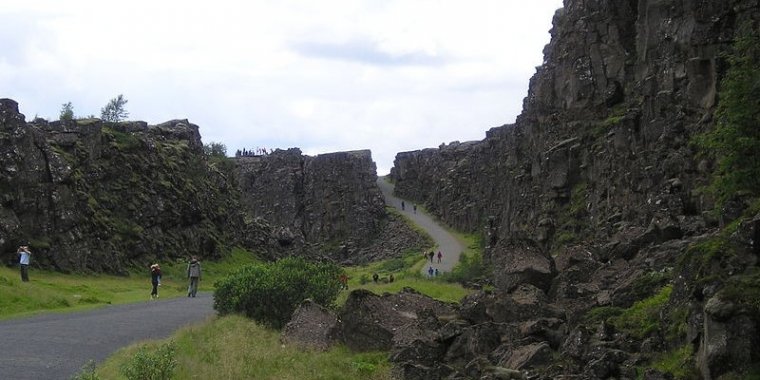
Þingvellir National Park. ![]()
What to Do in Þingvellir National Park
Have a look inside the Visitor Centre. It is in a new building close to the view spot at Hakið, where a footpath leads down into the great Almannagjá fault. The exhibition in the Visitor Centre is almost exclusively based on interactive multimedia and is the first of its kind in Iceland. The exhibition is therefore quite modern in design, although good care has been taken to make it easily accessible to the visitors.
The history and nature of Þingvellir and its surroundings literally "come alive" on large TV monitors, playing a wide variety of illustrative video and audio material. Using conveniently placed touch screens, you can choose narrative (and subtitles) in four different languages: Danish, English, German, French and Icelandic (a wider selection of languages will be added to the program later) then decide for yourself which particular sections of the multimedia program you want to view.
For instance, you might be prompted to "dive into" the habitat of lake Þingvallavatn and view unique close-up footage of fish in the lake, such as the brown trout. It takes about 40 minutes to view the whole multimedia program, but, as indicated before, visitors use the touch-screen interface to select which parts they prefer to view. Each program section is intended to provide the general national park visitor with some interesting and useful information about the subject at hand.
The exhibition is open daily from 09:00 to 17:00. Admission is free.
Take a walk around the old parliament seat and have a look inside the church which is open daily during the summer months. Every Sunday in the summertime there is mass in the church at 14:00 and all visitors are welcome.
Diving
Diving is permitted in two submerged rifts in the park, Silfra and Davíðsgjá. Silfra is one of the best spots for diving in Iceland and many people find the rift unique on an international scale.
The reason for its fame is the astounding visibility in the clear, cold ground water and the magnificent surroundings. Davíðsgjá is in the north-eastern part of Lake Þingvallavatn. The rift is in the lake itself and to reach it you have to swim some distance. It is quite shallow nearest to the bank, but deepens and widens further out.
Divers have to fulfil all regulations and conditions regarding qualification and equipment for diving. They must abide by all rules concerning diving and agree to respect the National Park regulations. It is prohibited to dive alone, to enter caves while diving and to dive to a greater depth than 18 m. You need to contact a guide if you wish to go diving in the rifts. Diving is entirely at the divers' own responsibility and risk.
• DIVE.IS, Hólmaslóð 2, 101 Reykjavik, +354 578 6200, e-mail: dive@dive.is. A PADI diving centre.
• Dive Silfra, Vatnagarðar 8, 104 Reykjavík, +354 519 6800, e-mail: info@divesilfra.is. Scuba diving and snorkelling club .
Buy
A fishing permit and have a go at the fish in the lake. You might catch charr for dinner or even one of the lake's famous brown trout.
Eat
A small café is in the Service Centre which sells hot dogs, soft drinks, sandwiches, cookies, ice cream and candy. The hotel has a restaurant and a café and is located on the outskirts of the main attraction (but it burned down in 2009), the old parliament site. The café/book-shop is a few kilometers past the visitor information center (if coming from the direction of Reykjavik).
Sleep
Lodging
No lodging in the national park is available but park rangers in the Information Center can provide information about lodging in the general area.
Camping
Camping is only permitted in two areas in the National Park. At Leirar, which is a 5-minute walk from the Information Center, and in Vatnskot, by lake Þingvallavatn. At Leirar there are four camping grounds: Fagrabrekka, Syðri-Leirar, Hvannabrekka and Nyrðri-Leirar. The Vatnskot camp ground is situated at an abandoned farm site by the lake.
Camping and angling permits should be obtained at the Information Center on arrival.
Children under the age of 13 can stay overnight, free of charge. Groups (10 adults or more) get a 15% discount if they pay in one sum at the time of reservation. The cost of camping is 1000 kr per person per night. If staying for more than three nights the fourth night is free of charge and every other night after that.
The camping grounds are mowed each week and the toilet facilities are cleaned at least once a day. Garbage does not have to be sorted before being put into the disposal cans, except that special containers for aluminum soda cans, glass bottles and plastic bottles are provided. Charcoal and ash from the barbecues should also be disposed of into separate containers.
During the summer Park Rangers look after the camping areas every day and during the weekends they keep nightshifts, to make sure everything is quiet after midnight.
Stay safe
When hiking in Þingvellir, you may encounter a variety of spectacular fissures in the ground. It might be tempting to lean over the edge and look into them, but be careful - the rocks near the edge may be unstable. Use your best judgement and watch out for your kids. (Wikivoyage)
YOU MAY ALSO LIKE


